
The Spider Camera: Revolutionising Mobile Mapping
A camera integrated into a seamless end-to-end solution
The Challenges of Cameras for Mobile Mapping
Mobile mapping presents several significant challenges for cameras, particularly when trying to capture high-quality, detailed images at high speeds. Many conventional camera systems struggle with:
- Low Parallax Control: Wide distances between lenses can cause stitching artifacts, leading to distorted panoramas.
- High Data Demands: Capturing high-resolution images generates vast amounts of data, often exceeding 2GB per second, which needs to be stored, compressed, and processed efficiently.
- Low Light Performance: Most cameras fail in poor lighting conditions, with motion blur and low sensitivity sensors making it difficult to capture clear images.
- Synchronization of Sensors: Capturing data from multiple sensors, including LIDAR and GPS, requires perfect synchronization to avoid misaligned images and incomplete data sets.
- Cost Efficiency: Balancing the need for cutting-edge technology with the constraints of budgetary limits is often difficult, especially when high-quality image capture and processing is essential.
- Camera Quality: Many government organizations are looking for a minimum of 100megapixels for quality
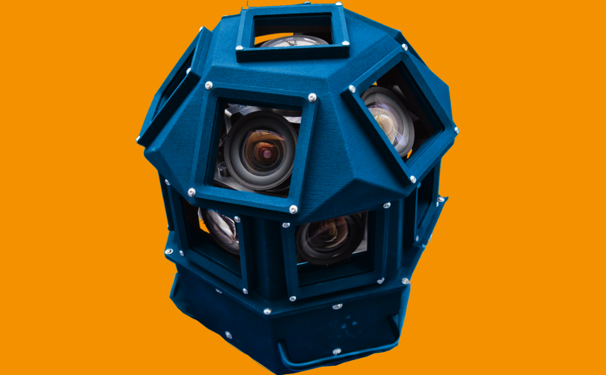
Introducing The Spider Camera
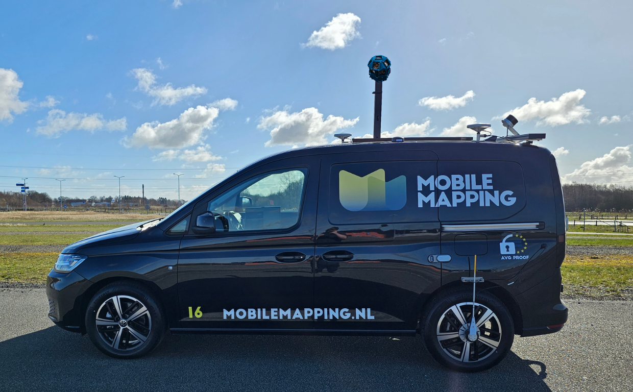
As part of our mobile mapping service, AI-InfraSolutions specializes in integrating the best-in-class sensors, including LiDAR, IMU, and GPS, and now our very own customized high-resolution robust 360-degree camera head – The Spider Camera.
Designed to meet the increasing requirements of global governments and infrastructure projects, this camera provides detailed imagery for AI-driven inspections and geospatial analysis.
Key Features:
- 180 MPix on panoramic images
- Seamless synchronization with multiple sensors
- Minimal parallax for precise stitching
- High frame rate, enabling accurate captures at speeds up to 100 km/h
- Low-light capability with reduced motion blur
Speak with an expert
Schedule a demo with Martin and learn more
Book a demonstration >


A Game-Changing Solution for Infrastructure Monitoring
Advanced AI-Driven Insights
The Spider camera isn’t just about high-quality imaging – it’s fully customized for AI applications. When paired with sensors like LiDAR and GPS, it produces "AI-ready" data that automatically interprets road conditions, traffic signs, and other infrastructure elements. Our system ensures that each image captured is perfectly synchronized, enabling our AI to analyze the environment more effectively than ever before.

Unrivaled Image Quality and Performance
Minimal Artefacts, Maximum Detail
The Spider camera’s 13-lens design significantly reduces stitching artifacts and parallax errors, ensuring that images are perfectly aligned for seamless panoramas. Compared to competitors like the Ladybug 6 and Google Street View, the Spider offers superior image clarity, capturing even the smallest details in road conditions and infrastructure assets.
Low-Light Performance and Adverse Weather Handling
Tested in low-light environments, the Spider camera delivers excellent results, even under challenging conditions. Its advanced exposure settings ensure high-quality image capture in varied lighting scenarios, allowing for clearer AI analysis.
Transforming Infrastructure Asset Management
By integrating all sensors such as LiDAR, IMU, and GPS with the Spider Camera, you have the ultimate mobile mapping system able to capture a wealth of synchronized data every 5 meters as it moves, making it ideal for a range of applications, including:
- Infrastructure Asset Monitoring
- Road Condition Assessment
- Vegetation and Tree Monitoring
- Traffic Sign Identification
This advanced system allows for automated inspections, reducing the need for repeat journeys and improving overall efficiency.

Success Factors
Our solution's success is built on several key factors:
- Open Collaboration: Strong partnerships with best-of-breed partners such as STEMMER IMAGING and other technology providers.
- Advanced Solutions: Access to customizable technologies beyond current market offerings.
- Virtual Simulations: Reducing investment in feasibility studies through proven simulation workflows.
- Expertise: Leveraging STEMMER IMAGING’s technical know-how.
- Seamless Integration: Efficiently combining sensors and mobile mapping software for a complete solution.
Shaping the Future of Geospatial Mapping
AI-InfraSolutions is at the forefront of geospatial mapping innovation, combining cutting-edge camera technology with AI-driven insights to deliver precise, reliable data. Our system enables high-speed, high-resolution data capture, transforming the way infrastructure is monitored and maintained.
Discover how our solutions can revolutionize your approach to mobile mapping.