Revolutionizing Geospatial Mapping with Machine Vision
AI-InfraSolutions helps infrastructure professionals and mobile mapping companies create a safer, more sustainable world by providing intelligent geospatial insights that improve the safety and efficiency of infrastructure management activities worldwide. This is achieved by providing enriched reality data that can be translated into useful insights for the operational maintenance of infrastructure assets, such as traffic sign identification, road condition assessment, vegetation assessment, tree monitoring, road markings, and other such assets.
Building on its successful end-to-end mobile mapping service in the Netherlands, AI-InfraSolutions is now partnering with mobile mapping companies globally to deliver a sustainable and scalable methodology for large-scale mapping (in conjunction with AI-driven data insights) to governments and large-scale organizations worldwide.
As part of their end-to-end mobile mapping service, AI-InfraSolutions specializes in integrating top-of-the-range sensors to provide the best solutions for the job. Some of these sensors include LiDAR, IMU and GPS.

The task
AI-InfraSolutions is designing a high-resolution 360-degree camera head capable of acquiring detailed imaging data. This data, when combined with other sensors, serves as the foundation for AI-driven inspections that automatically gather various types of information.
The challenge
AI-InfraSolutions faced several technical challenges in developing the 360-degree camera head:
Hardware Selection/Design
Finding the best combination of camera sensors, lenses, and interfaces and determining their optimal positions and orientations within a 360-degree setup.
Key requirements
- Capture sharp images at specified working distances (2 to 40 meters).
- Produce a final panoramic image of over 150 MPix.
- Ensure large spatial coverage (H x V: 360° x 120°) with sufficient overlap for efficient stitching.
- Maintain low parallax angles to avoid stitching artifacts.
- Capture high-frame-rate images to enable acquisition every 5 meters at driving speeds of up to 100 km/h.
- Synchronize the cameras perfectly with each other and with external GNSS positioning systems.
- Use high-sensitivity sensors to reduce exposure times and minimize motion blur in low-light conditions.
- Cost Minimization: Achieving all technical requirements while keeping costs as low as possible.
The solution
STEMMER IMAGING provided the design, layout, and manufacturing of the technology that enabled Mobile Mapping to reliably inspect roads and surrounding environments using seamless, high-quality images. This solution significantly improved the analysis of 360-degree images in urban, industrial, and road settings, offering much more visual detail compared to competitive camera units. The camera head allows continuous high-speed recording for up to 247 km (optionally expandable to 496 km), ensuring reliable image acquisition without the need for duplicate trips.
- Integrated and Compact Machine Vision System: Ensures ease of installation and use in mobile mapping applications.
- Precise Intrinsic Calibration: Enables improved and reliable panoramic stitching by removing perspective distortions in raw images.
- High-Speed Measurement Frequency: Supports rapid data capture to keep up with driving speeds.
- Optimized Control of Camera Settings: While post-processing tasks such as tone mapping and stitching are done offline, real-time control is focused on adjusting camera system settings, such as auto-brightness, to ensure optimal image quality during data collection.
Proven Simulation Workflows: Virtual simulations allow for pre-testing design modifications before implementation, reducing physical prototyping costs.
How it works
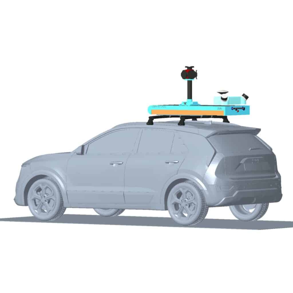
The camera head is mounted on top of a vehicle, and integrated with additional sensors like LiDAR, IMUs, and GNSS. As the vehicle moves, it captures synchronized images every 5 meters, optimized based on the current conditions. These images are linked with data from other sensors and stored in real time on a RAID system. Although the images are stored online during data collection, post-processing tasks such as tone mapping and stitching are performed offline for enhanced image quality and detail. Once processed, the data is ready for further analysis in various applications.
AI-InfraSolutions then prepares this data to be “AI-ready” and automatically interprets it for various applications, including:
- Infrastructure Asset Management: Monitoring and maintenance of infrastructure assets
- Road Management: Assessment and management of road conditions.

“We are proud to partner with Stemmer Imaging to redefine the possibilities of high-quality mobile mapping at scale. By combining our innovative approach with Stemmer Imaging’s leading vision, we are elevating our solutions to an unmatched level.”

Innovating Geospatial Mapping with Machine Vision
The keys to the success of this solution are:
- Open Communication: Effective collaboration between AI-InfraSolutions and STEMMER IMAGING.
- Advanced Solutions Availability: Access to STEMMER IMAGING’s extensive catalogue and willingness to develop customized solutions beyond current market offerings.
- Virtual Simulations: Reduced investment in research and feasibility studies through proven simulation workflows.
- Expertise: Leveraging the expertise of STEMMER IMAGING’s team.
- Supplier Network: Benefit from STEMMER IMAGING’s network of suppliers and service providers.
- Seamless Integration: Efficient integration of STEMMER IMAGING’s technology with the final Mobile Mapping software.
Success factors
Geospatial mapping technologies are revolutionizing how we capture, analyze, and interact with spatial data. By enabling the creation of highly accurate three-dimensional models and maps with real-color textures, these advancements are critical for better planning, monitoring, and decision-making in industries such as agriculture, construction, and urban planning.
STEMMER IMAGING’s machine vision expertise plays a vital role in capturing and processing high-resolution imagery for geospatial mapping. We help businesses improve efficiency, accuracy, and insights by delivering precise and reliable data. By integrating our advanced machine vision systems with comprehensive support and services, we assist our partners in navigating the complexities of artificial vision in the modern world. Together, we turn innovative ideas into tangible realities, driving progress and shaping a smarter future.
